How to get involved again
Meath County Council, in conjunction with its Design Team, will hold a public consultation on the Julianstown Traffic Relief Scheme at Matt the Thresher, Main Street, Julianstown West, Julianstown, on 8 July, from 3:00 pm to 8:00 pm.
Submissions can be made via a survey, which will be available both at the consultation event and online. Surveys may be submitted on the day or at any time up to 31 July by post or online using this link.
By Post
Transportation Department
Meath County Council
Buvinda House
Dublin Road
Navan
Co. Meath
C15 Y291
By Email
transport@meathcoco.ie (Please reference “Julianstown Traffic Relief Scheme” in the subject line of your email.)
What happens next?
There will be a further opportunity for the public to engage with the scheme as it progresses through Phase 2. This will follow the identification of an Emerging Preferred Option, which will include proposed traffic-calming measures and public realm improvements within the village.
Following the completion of Phase 2 and the identification of a preferred option, the project will progress to Phase 3 – Design and Environmental Evaluation, subject to approvals and funding.
The purpose of this phase is to develop the design of the Preferred Option, including the layout and junction arrangements, and to undertake a detailed environmental evaluation. This work will assist in establishing land-take requirements and support advancement of the project through the statutory approval process. During Phase 3, ongoing engagement with landowners, stakeholders and other interested parties will continue as part of the design development process.
Further information
The Julianstown Traffic Relief Scheme team will consider all of the submissions made during the public consultation period. The feedback received will be used to inform the project’s design to progress towards the next stage of development to identify a Preferred Option. A report will be published summarising the feedback received during this consultation and how it informed the design and development
First public consultation outputs
Over 1,100 Julianstown residents, workers, and visitors participated in a widely promoted local travel survey in early 2026. The consultation gathered insights on how respondents travel, what access they have to vehicles and if they agreed with the objectives and statements about travel in Julianstown.
Respondents were asked how strongly they agreed or disagreed with a number of statements (see figure below) about travel in Julianstown. Responses from people who live in Julianstown were separated from those who travel through, visit or work there, to assess the different views of the two groups. Across all respondents, 99% agreed that there was congestion through Julianstown. As the statements moved towards more localised points, for example feeling safe to walk or cycle or ease of crossing the road, the responses became more distinct.
74% of residents disagreed that they feel safe walking through the village compared to 50% of other respondents. 87% of residents agreed that local traffic discourages walking and cycling through Julianstown compared to 58% of non-residents. Further results are shown in the graph.
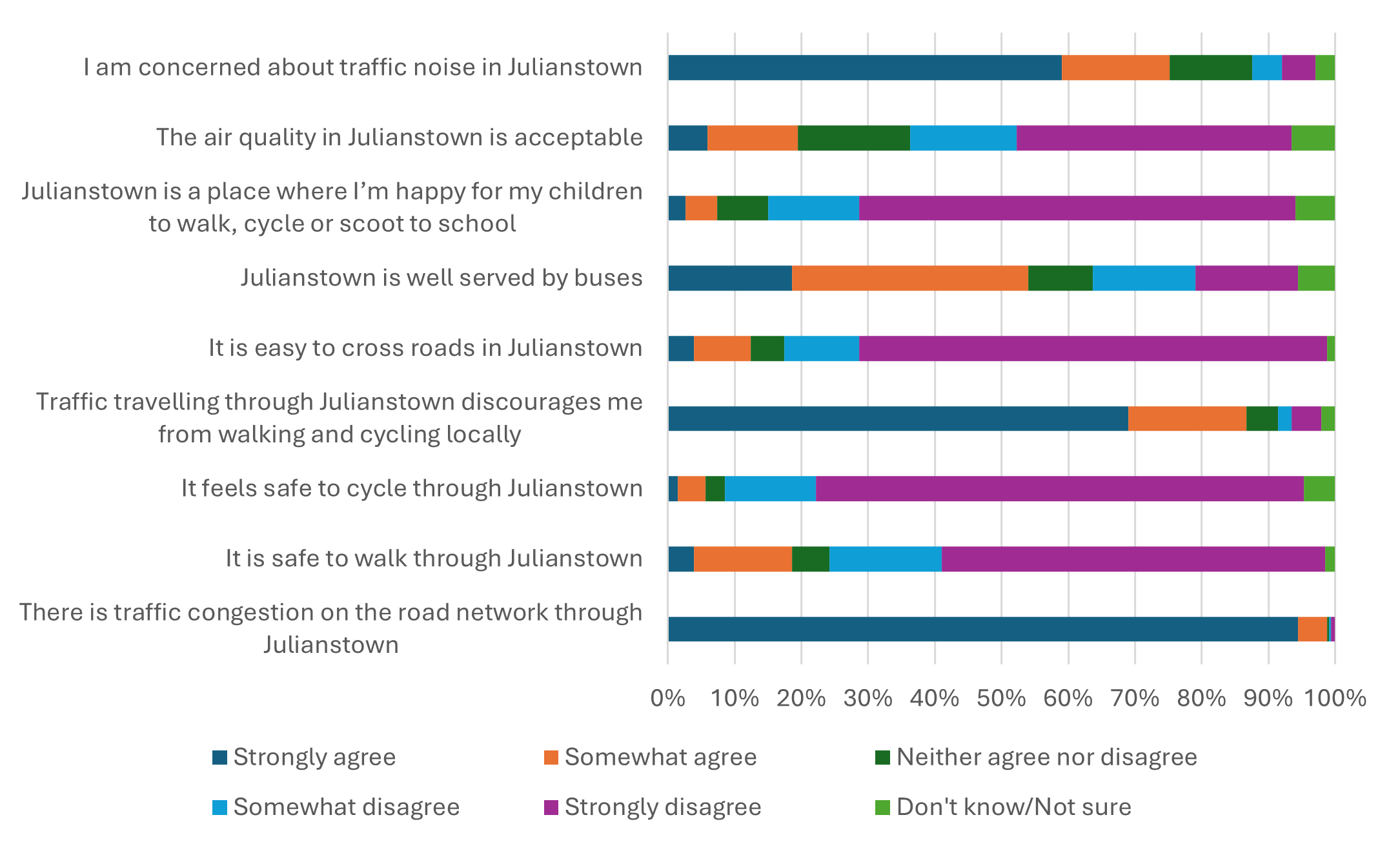
These results show that users of the R132 are impacted differently depending on their association with Julianstown, with local residents more likely to view walking, cycling, air and noise quality in the area as more impactful than those visiting and travelling through Julianstown.
Respondents were also invited to share additional constraints or relevant information. These insights were categorised into the following themes and integrated into the project:
M1 Toll
Environmental and Heritage
School / School Safety Constraints Raised
Active Travel Safety & Provision
Public Transport